Telemetry tools for Insta360
Display GPS and sensor metrics on 360, reframed and action videos. Convert the data to other formats
Download nowScroll down for more products
Insta360 support within the Telemetry software
Most of the recent Insta360 cameras can record GPS data if paired with a compatible GPS-enabled remote: One X5, Ace Pro 2, One X4, Ace / Ace Pro, One X3,, Go 3, One RS, One R, One X2, One X, Pro 2, Pro. Other models may also be supported. The GPS data is recorded if the setting is enabled and a compatible device is linked: the GPS Action Remote, GPS Preview Remote wiht Built-in Mic, GPS Preview Remote, the old GPS Smart Remote, the mobile app, one of the smartwatch apps...
You can add telemetry gauges to full 360 videos, reframed videos, or to your preexisting professional 360 workflow (Adobe Premiere, Final Cut Pro, etc.). See the relevant tutorials.
Additionally, accelerometer and gyroscope data are generally recorded when shooting in INSV format or Pro/FlowState stabilization.
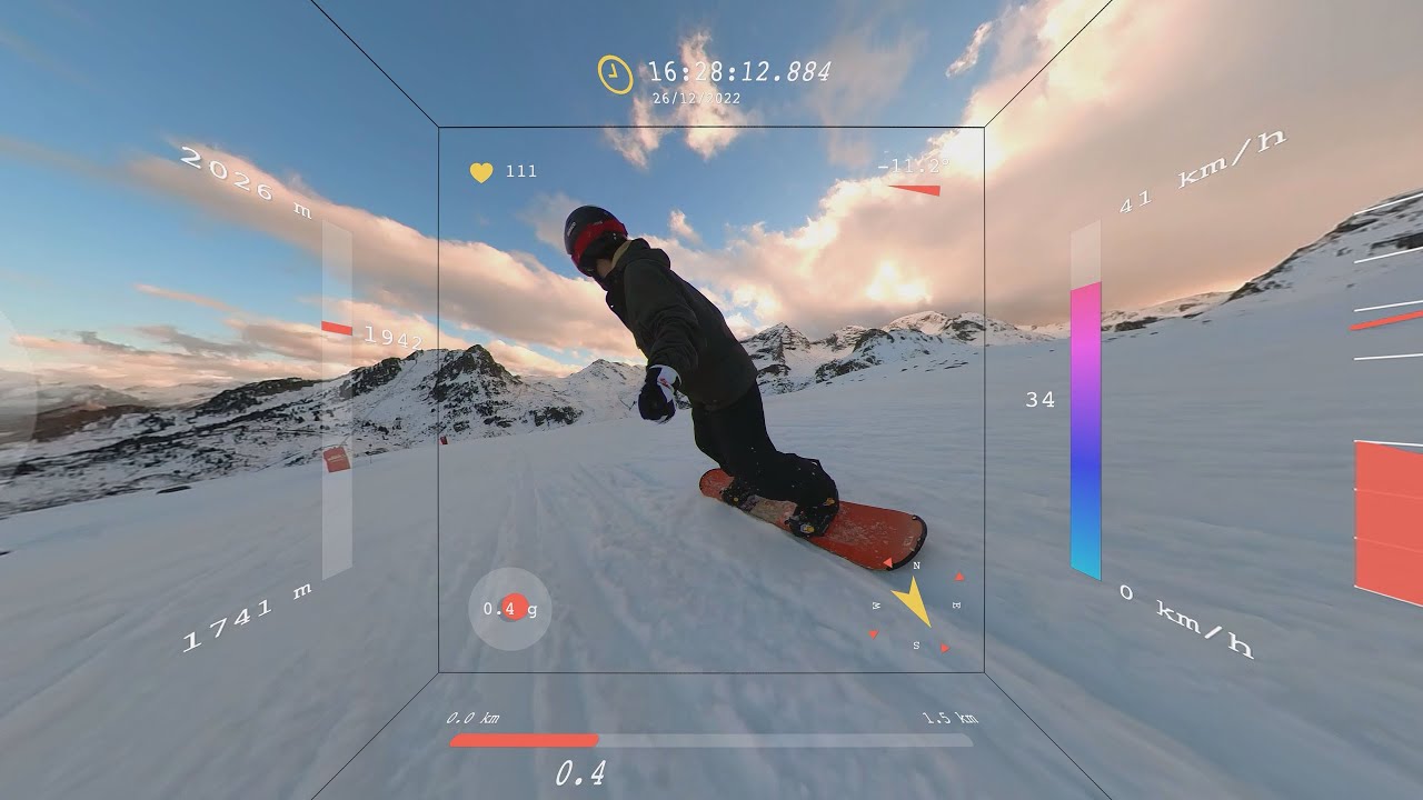
Supported gauges in Telemetry Overlay
Speedometer, GPS Path, Accelerometer, Altitude, Distance, Slope, Dynamic Map, Gyroscope, Bearing, Acceleration (GPS), Time & Date, Lap Timer, Pace, Vertical Speed, Elevation Gain, Coordinates, Altitude vs Distance, Lean Angle (2 wheel), Airspeed, Altimeter, Heading Indicator, Turn Coordinator, Vertical Speed Indicator, Longitudinal Acceleration (GPS), Acceleration (speed-based), Lateral Acceleration (GPS), Zero to Speed, Distance Timer, GPS Path + Compass, Distance Home, Sector Times, Corner Speeds, Shutter Speed, Custom, Dynamic Text, Static Title, Static Image, Export GPX, Embed Timecode and Watermark.
Availability may vary between devices and recording conditions.
Readable streams in Telemetry Extractor
Actual availability will depend on the hardware used, recording mode, and conditions. Some of these streams are native and some will be computed, with varying degrees of accuracy. Streams not listed here will also be available in some cases.
Date & time, Latitude, Longitude, Altitude, Speed, Bearing, Accelerometer X, Accelerometer Y, Accelerometer Z, Gyroscope X, Gyroscope Y, Gyroscope Z, Shutter Speed, Slope or grade, Accumulated distance, Accelerometer sum, Acceleration (speed-based), Vertical Velocity, and custom formulas.
If recording GPS data with the Insta360 mobile app, be aware that the GPS Activity Stats feature does not send the data to the camera. It just keeps it on the phone. Make sure to go into the camera preview, enable GPS recording from the settings, start and stop the recording from the mobile app, and keep the phone screen on for the entire recording.
If using a non-360 lens or shooting mode (4K, 1 Inch, Steadycam), note that the Insta360 app is only capable of recording the GPS data if the Pro mode (or Active HDR video) is enabled, not Basic or Quick. These modes can be changed from the camera itself (not the app) by clicking on the resolution. When using the GPS Remote, GPS data is recorded even if the Basic/Quick mode is selected. Another important limitation of the phone app is that the phone needs to have the screen on for the entire recording. Otherwise the data is not recorded correctly. For these reasons, the GPS Remote or even the smartwatch apps are recommended.
Some Insta360 models record the data to the LRV file instead of the main video. In those cases import the main video first and then the data by selecting the LRV from the Telemetry section.
More about Telemetry Overlay
Telemetry Overlay supports most video formats and dozens of embedded and external data formats.
Gauges can be customized to a great extent, but presets and defaults can make the user experience extremely easy.
Map and satellite imagery is available for representing GPS data.
Export formats for both professional and social use are available.
Lots of documentation, tutorials and an active community help achieve great results.
More about Telemetry Extractor
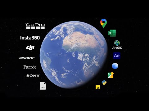
Telemetry Extractor can convert camera metadata (and other sources) to multiple professional data file formats, like GPX, CSV, KML, JSON, MGJSON...
This enables integration with software packages like Google Maps, Google Earth, Google Street View, Excel, Numbers, Google Sheets (and other spreadsheet programs), ArcGIS (and other mapping software), programming languages, Adobe After Effects, Kinomap, fitness websites and much more.
In addition to the raw recorded data, it can compute new streams by processing the existing data, like distance, bearing, or slope from GPS.
The data is presented in a visual and interactive way. You can click on customizable maps and charts to move the video to that position.
Have more questions? Check out the Instructions manual (Telemetry Overlay, Telemetry Extractor), the tutorials, ask the community, experiment with the Trial (Telemetry Overlay), or get in touch.
Telemetry Overlay
Finally! An easy all-in-one way to create a heads-up display for your action videos and drone footage. Compatible with multiple camera brands and data formats, including GoPro, DJI (drones and Action 4/5/6/360), Insta360, Garmin, GPX and many more. Merge consecutive videos with GPS data, sync telemetry from multiple sources, customize your gauges and much more. | Learn more
$299$199
Currency conversion may applyPay once
Use forever
1 Year Updates & Support
Download Telemetry Overlay

Purchase for Windows
Win 10, 11, 12...

Purchase for macOS
Apple Silicon & Intel

Purchase for Linux
DEB & RPM packages
Telemetry Extractor
Convert the sensor data recorded by GoPro and many other cameras (GPS, Accelerometer, Gyroscope, camera settings and more) to formats for Google Earth/Maps, Excel, Numbers, Calc, ArcGIS, After Effects, Kinomap, and more mapping and data software. Interact with data graphs and GPS maps of the video, filter out bad data and compute new streams. Merge the data of consecutive videos quickly for data-intensive analysis workflows. | Learn more
$449$349
Currency conversion may applyPay once
Use forever
1 Year Updates & Support
Download Telemetry Extractor
Purchase for Windows
Win 10, 11, 12...
Purchase for macOS
Apple Silicon & Intel
Purchase for Linux
DEB & RPM packages
Tutorials
Learn to use the software

Learn to create both reframed and professional 360 videos with data

Hugh Hou shares his workflow from Telemetry Overlay to Davinci Resolve
Telemetry Extractor can display 360 video projections
Which product do I need?
Telemetry Overlay
Telemetry Extractor
User Reviews
Professionals and hobbyists alike are joining the Telemetry club