What can Telemetry Extractor do?
Extract camera GPS and sensor data to use it in Google Maps/Earth/Street View, Excel, Numbers, Sheets, Calc, GIS, After Effects, Kinomap...
What cameras are supported as an input?
Dozens of data-enabled cameras are supported. These are some of the most common ones:
- GoPro: MAX2, Mission, HERO13, HERO12, HERO11, HERO10, HERO9, HERO8, HERO7, HERO6, HERO5, Max & Fusion
- DJI: Osmo Action 4/5/6/360, Mavic (Air 2/3/s, Pro/Zoom 2/3/4, Mini, Pro), Neo/2, Avata/2/360, Mini 2/3/4/5/Pro, FPV, Phantom (3, 4, Pro), Inspire, Matrice 200
- Insta360: One X5, One RS, One R, One X4, X5, One X3, Go 3, One X2, One X, Ace, Pro/2...
- GPX: GPS track data & more
- Dashcams GPS-enabled cameras and more!
If your device/format is not listed, check the full list in the compatibility list, the instructions manual or get in touch.
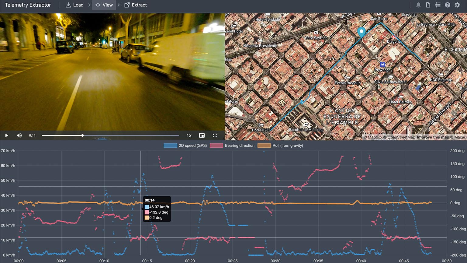
Can I visualize the data before exporting it?
Yes. You can view an interactive map with GPS locations synced to the video, and musltiple chart types for other sensors and streams. Clicking on the map or charts updates your position in the video so you can identify significant events.
Specific frames with embedded (geotagging) data can be extracted from the preview window
360 videos (equirectangular and some more projections) can also be displayed natively within the video player.
What can I do with the data after exporting it?
There are hundreds of possible use cases and your imagination is the limit, but here are some common ones:
- Display the data on Google Maps, Google Earth, or Google Street View
- Convert the camera sensors to CSV for analysis in Excel, Numbers, Sheets, Calc... or even ArcGIS
- Extract the GPS route to formats like GPX or KML to use it in GIS or fitness websites
- Export the data to MGJSON format to use it in Adobe After Effects
Are Google Maps available?
MapBox maps are available. They have a wide range of map styles and also satellite imagery. The map is easily zoomable, tiltable, and can have 3D elements. If necessary, create your own map style in MapBox Studio and import it for your videos.
Does Telemetry Extractor create videos with visual metrics?
Generally speaking, no. For that, use Telemetry Overlay instead. However, Telemetry Extractor includes an Adobe After Effects template and it can export data to the MGJSON format, which only proficient After Effects editors should use.
Are new features coming to the software?
Yes. New features and format support are frequently added to the program. You may suggest new features, but be aware that the wish-list is really long, so not everything will be possible and most things will take time.
Is an iPhone/iPad/Android version available?
No. Windows, MacOS and Linux for now.
What formats can the data be extracted to?
- GPX (GPS Exchange Format) GPS route files compatible with endless mapping, fitness, and data software options. Great for timed data
- CSV (Comma Separated Values) Spreadsheet format compatible with Excel, Numbers, Calc, ArcGIS, and many more
- Frames Still photos (as PNG or JPG files) at the chosen time or distance interval, with either embedded (geotagged) data, or a side file with all the values (CSV, JSON), or the data overlaid as text
- KML (Keyhole Markup Language) Basic GPS route files compatible with Google Earth, Maps and more. Good for static data representations
- mgJSON (After Effects animation) Motion Graphics JSON for Adobe After Effects expression scripting and templates
- JSON (JavaScript Object Notation) Comprehensive data format based on JavaScript objects, good for complex customizations
- geoJSON Open standard format designed for representing simple geographical features
Which sensors/streams are available?
Depending on your camera model you will have some of these: GPS (latitude, longitude, elevation, speed), gyroscope, accelerometer, exposure time, white balance (Kelvin and RGB), sensor ISO camera orientation, and many more.
Many more streams can be computed from the existing raw data. For example, having GPS coordinates and altitude enables bearing direction, accumulated distance, slope... having camera orientation enables pitch and roll, etc.
Can multiple videos and their data be loaded together?
Yes. Consecutive videos can sbe imported all at once and the program will create continuous maps, charts and a single exported file. If the videos are not consecutive, it's best to load them in different projects, but you can automate this with the Batch Loader and extract them as a single data file within the extraction Queue.
Can the GPS data be improved?
To some extent. The software has controls for filtering out bad GPS data points. This depends on your data source, but it can be the number of satellites or the dilution of precision. You can also apply some smoothing to hide small data inaccuracies. In extreme cases, the only solution is to record a better GPS signal.
Is there an Adobe Premiere/Davinci Resolve/Final Cut Pro template?
No. For that, use Telemetry Overlay and export the project to one of the transparent video formats, for a lossless integration.
If there a user forum of the software?
Yes, check out the Facebook community.
Is this a subscription or a one-time payment?
Pay once. Use forever!
Plus, get updates and support for one year, then optionally extend them for a fraction of the initial cost.
Have more questions? Check out the instructions manual, the tutorials, ask the community, or get in touch.
$449$349
Currency conversion may applyPay once
Use forever
1 Year Updates & Support
Download Telemetry Extractor

Purchase for Windows
Win 10, 11, 12...

Purchase for macOS
Apple Silicon & Intel

Purchase for Linux
DEB & RPM packages
Tutorials
Learn to use the software
Record good GPS data with GoPro cameras

All 3 major action camera brands support some level of GPS data in 2024
Top new features of Telemetry Overlay and Telemetry Extractor
Which product do I need?
Telemetry Overlay
Telemetry Extractor
User Reviews
Professionals and hobbyists alike are joining the Telemetry club