How to use GoPro GPS and sensor data in After Effects?
Convert your data with Telemetry Classic or Telemetry Lite and use the Telemetry Template to handle it within AE
Which GoPro cameras are supported?
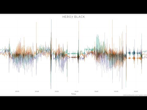
These cameras contain GPS, accelerometer, gyroscope, ISO, shutter speed and more data: MAX2, HERO13, Mission, HERO11, HERO10, HERO9, HERO8, HERO7 Black, HERO7 Silver, HERO6 Black, HERO5 Black, Max and Fusion.
These cameras contain accelerometer, gyroscope and in some cases camera settings: HERO12 Black, LIT HERO, HERO (2024), HERO11 Mini, HERO10 Bones, HERO5 Session and HERO7 White.
How to convert the data for After Effects?
You can load, visualize and convert your data with Telemetry Extractor for faster and more comprehensive results, or the free Telemetry Lite for basic functionality.
There, export your data to the After Effects format (mgJSON)
Why use Telemetry Extractor vs. the Telemetry Lite?
Mostly because it can join the data of consecutive videos as a single MGJSON file, so you can create longer, more comprehensive visualizations. It also reads data from many more brands, can visualize it dynamically alongside the video and process it in many ways.
Can the project be longer than 1 hour?
Yes. Expand the duration of your composition from its settings, unhide and unlock all the hidden layers and extend their duration as well.
Keep in mind that Adobe After Effects cannot import mgJSON files longer than 3 hours. If that is what you need, either find a way to compress the duration of your data before converting it to mgJSON, or use Telemetry Overlay instead.
Is there an easier alternative?
Yes. Telemetry Overlay allows you to create your data dashboard without the need of third-party professional tools like After Effects. It has an easy drag-and-drop interface, hundreds of customization options and more gauge options and data types.
Can I share my video with telemetry somewhere?
Yes, please! The Facebook community is probably the best place to do so, but if you prefer to do it somewhere else, get in touch to increase your audience.
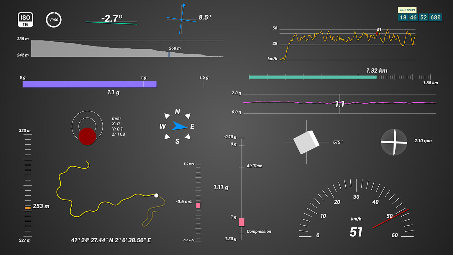
What gauges are included?
Depending on your camera model, these are the available streams:
- GPS: Speed, Distance, Altitude, GPS Path, Altitude Path, Course Direction, Speed Tracker, Vertical Speed, Slope, Time
- Accelerometer: G-Force, Acceleration, Air Time, G-Force Path
- Gyroscope: Rotation, Total Rotated, Lean Angle (experimental)
- Shutter speed, ISO: Camera Settings
How to load the data in AE?
Use the After Effects template to select the gauges you want to display, import the MGJSON file, drop it into the desired gauge composition and use the Control layer's effects panel to set the imported data as a source and customize how it looks.
What software do I need in order to run this?
Adobe After Effects 2020 or newer.
Can the GPS Path show satellite images or Google Maps?
Not easily. For that, use Telemetry Overlay instead.
Is this a subscription or a one-time payment?
Pay once. Use forever!
Plus, get support for one year, then optionally extend it for a fraction of the initial cost.
Have more questions? Check out the instructions manual, ask the community, experiment with the Trial version, or get in touch.
$69
Currency conversion may applyPay once
Use forever
1 Year Support
Download Telemetry Template for GoPro (Adobe AE)

Purchase Full Template
Available now
Examples
See what other users have created
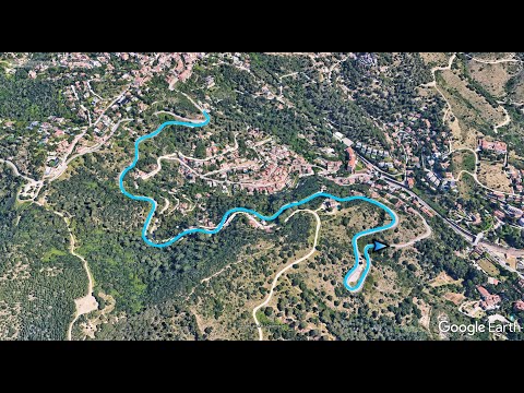
Combine the After Effects gauges with a Google Earth 3D map to create an even cooler video
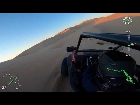
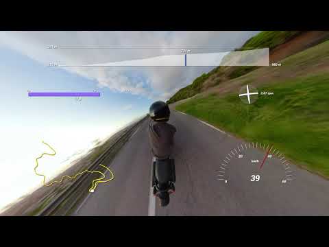
Mike shows off the performance of his SxS vehicle and his skills in the desert
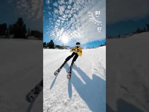
Abe Kislevitz films himself skiing at 121 km/h (75 mph)

GPS and sensor data in drone videos provides additional context and enhances the experience
The custom HUD creates a videogame-like experience in this 3rd person video
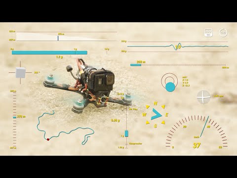
FPV freestyle drones are a great opportunity to show off forces in a dashboard
The Telemetry Classic for GoPro promo video was created with this very template

Dude Perfect (50 million subscribers) customized their telemetry gauges in this fighter jet video
Which product do I need?
Telemetry Overlay
Telemetry Extractor
User Reviews
Professionals and hobbyists alike are joining the Telemetry club