What does Telemetry Classic for GoPro do?
Your GoPro files contain much more than just video. Telemetry Classic for GoPro reads the GPS, accelerometer and other sensor data from your videos and converts it to other formats for advanced work
How does this compare to the new Telemetry Extractor?
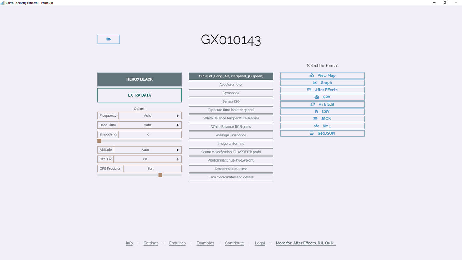
The new version of Telemetry Extractor can read data from many more devices (Insta360, DJI, GPX...), visualize it alongside the video with interactive maps and charts, process it in many ways to clean it up or create new values, and it is actively being developed for more features and support.
What format is the data in?
The data is embedded in the video file in a custom format by GoPro, but with Telemetry Classic for GoPro you can export it to:
- GPX (GPS Exchange Format)
- KML (Keyhole Markup Language)
- CSV (Comma Separated Values)
- JSON (JavaScript Object Notation)
- mgJSON (After Effects animation)
- geoJSON
- PNG (Graph)
- WebM (GPS map video)
The GPS data looks bad or is missing. Why?
- Turn on the GPS in the Regional settings of your camera
- Record in an open space without obstacles
- Make sure the GPS icon (location pin) is bright white before pressing record
- Do not place your camera upside down and do not cover its top. The antenna is next to the record button and needs to "see" the satellites in the sky
- Do NOT use the QuickCapture setting (turning ON the camera with the record button), it does not give the camera enough time to find the GPS satellites
- Do NOT use the Media Mod or place anything around/over the camera, it can interfere with the GPS signal
- Warning! The GoPro HERO12 Black does NOT record GPS data. Choose a GoPro HERO11 or GoPro HERO13 if you can.
What can I do with the data after exporting it?
There are hundreds of possible use cases and your imagination is the limit, but here are some common ones:
- Export the data to MGJSON format to use it in Adobe After Effects, potentially with the Telemetry Templates
- Extract the GPS route to formats like GPX or KML to work with it in GIS (Geographic Information System) software, like ArcGIS
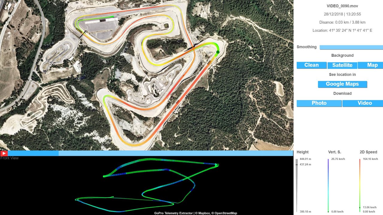
- Display the data on Google Maps or Google Earth, even as a 3D animation
- Use the location, gyroscope and accelerometer data to analyze events like car crashes
- If Telemetry Overlay is not "your cup of tea", export the data to GPX to use it in other video dashboard software options like Virb Edit or Dashware
Is this a subscription or a one-time payment?
Pay once. Use forever!
Plus, get support for one year, then optionally extend it for a fraction of the initial cost.
Which cameras contain GPS data?
These cameras contain GPS and more data: MAX2, Mission, HERO13 Black, HERO11 Black, HERO10 Black, HERO9, HERO8, HERO7 Black, HERO7 Silver, HERO6 Black, HERO5 Black, Max and Fusion.
These cameras contain some data (accelerometer, gyroscope) but not GPS: HERO12 Black, LIT HERO, HERO (2024), HERO11 Mini, HERO10 Black Bones, HERO5 Session and HERO7 White.
The HERO4 Black can record metadata into the videos if attached to a Bluetooth metadata device, but this has not been thoroughly tested. All the other mentioned cameras can do this too.
Test your video files with the free Telemetry Lite for GoPro.
Which sensors/streams are available?
Depending on your camera model you will have some of these: GPS (latitude, longitude, elevation, speed), gyroscope, accelerometer, exposure time, white balance (Kelvin and RGB), sensor ISO, average luminance, image uniformity, scene classification, face coordinates and smiles, predominant hue, camera orientation, image orientation, gravity vector, wind processing, microphone wetness, AGC audio level, disparity matrix...
Can Telemetry Classic for GoPro export a video with gauges?
Not directly. For that, use Telemetry Overlay instead. It is a user friendly, yet professional tool for creating your custom overlays, not just for GoPro cameras but for many compatible data sources.
Yes. You can merge the extracted data with Telemetry Classic for GoPro. The original videos do not get merged. If you need to also merge the video footage and display continuous data, use Telemetry Overlay.
Have more questions? Check out the instructions manual, the tutorials, ask the community, experiment with the Trial version, or get in touch.
$299
Currency conversion may applyPay once
Use forever
1 Year Support
Download Telemetry Classic for GoPro

Purchase for Windows
Win 10, 11, 8 & 7

Purchase for macOS
10.11 and newer
Tutorials
Learn to use the software
Here are some best practices for improving your results with GPS data
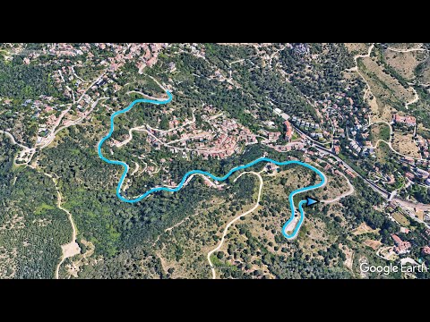
Extract your data to GPX to create an amazing 3D map in Google Earth
Comparison between GoPro, Insta360 and a Garmin watch, involving Telemetry Extractor
Which product do I need?
Telemetry Overlay
Telemetry Extractor
User Reviews
Professionals and hobbyists alike are joining the Telemetry club