Three templates in one
Create telemetry projects in After Effects with 3 different workflows: GoPro, DJI and GPX files. Scroll down to find information about each workflow and answers to common questions.
What software do I need in order to run this?
Adobe After Effects 2020 or newer.
Can the GPS Path show satellite images or Google Maps?
Not easily. For that, use Telemetry Overlay instead.
Is this a subscription or a one-time payment?
Pay once. Use forever!
Plus, get support for one year, then optionally extend it for a fraction of the initial cost.
Can the project be longer than 1 hour?
Yes. Expand the duration of your composition from its settings, unhide and unlock all the hidden layers and extend their duration as well.
Keep in mind that Adobe After Effects cannot import mgJSON files longer than 3 hours. If that is what you need, either find a way to compress the duration of your data before converting it to mgJSON, or use Telemetry Overlay instead.
Is there an easier alternative?
Yes. Telemetry Overlay allows you to create your data dashboard without the need of third-party professional tools like After Effects. It has an easy drag-and-drop interface, hundreds of customization options and more gauge options and data types.
Can I share my video with telemetry somewhere?
Yes, please! The Facebook community is probably the best place to do so, but if you prefer to do it somewhere else, get in touch to increase your audience.
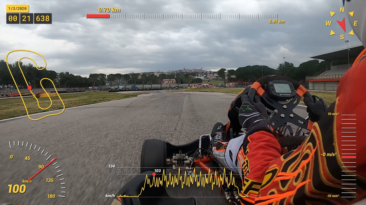
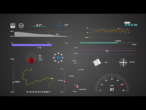
GoPro workflow
Record with GPS-enabled GoPro cameras and prepare the data for After Effects with Telemetry Classic or Telemetry Lite.
Which GoPro cameras are supported?
These cameras contain GPS, accelerometer, gyroscope, ISO, shutter speed and more data: MAX2, HERO13, Mission, HERO11, HERO10, HERO9, HERO8, HERO7 Black, HERO7 Silver, HERO6 Black, HERO5 Black, Max and Fusion.
These cameras contain accelerometer, gyroscope and in some cases camera settings: HERO12 Black, LIT HERO, HERO (2024), HERO11 Mini, HERO10 Bones, HERO5 Session and HERO7 White.
How to convert the data for After Effects?
You can load, visualize and convert your data with Telemetry Extractor for faster and more comprehensive results, or the free Telemetry Lite for basic functionality.
There, export your data to the After Effects format (mgJSON)
Why use Telemetry Extractor vs. the Telemetry Lite?
Mostly because it can join the data of consecutive videos as a single MGJSON file, so you can create longer, more comprehensive visualizations. It also reads data from many more brands, can visualize it dynamically alongside the video and process it in many ways.
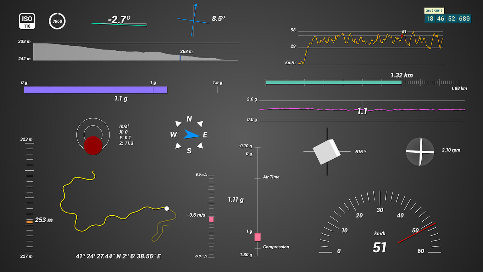
What gauges are included?
Depending on your camera model, these are the available streams:
- GPS: Speed, Distance, Altitude, GPS Path, Altitude Path, Course Direction, Speed Tracker, Vertical Speed, Slope, Time
- Accelerometer: G-Force, Acceleration, Air Time, G-Force Path
- Gyroscope: Rotation, Total Rotated, Lean Angle (experimental)
- Shutter speed, ISO: Camera Settings
How to load the data in AE?
Use the After Effects template to select the gauges you want to display, import the MGJSON file, drop it into the desired gauge composition and use the Control layer's effects panel to set the imported data as a source and customize how it looks.
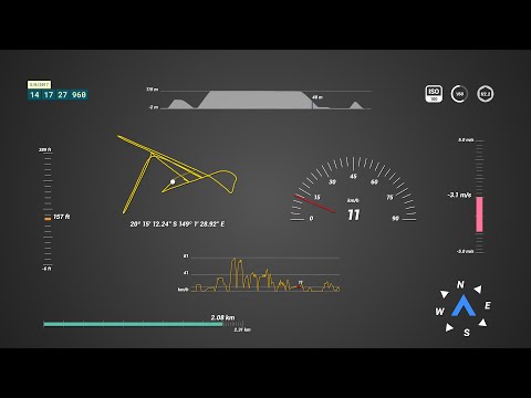
DJI workflow
Record drone flight logs as video subtitles from the DJI app and prepare them for After Effects with the DJI SRT Viewer.
Which drones are supported?
- Mavic (Pro, Air 2, 2 Pro/Zoom, 3, 4, Mini)
- Air (2, 2s, 3, 3s)
- Mini 2/3/4/5/Pro
- Neo (2 & 1)
- FPV/Avata/2/360
- Phantom (3, 4, Pro)
- Inspire
- Matrice
Some drones record the data in a separate .SRT file (caption, subtitles), while others embed it in the MP4 video file.
How to record the data?
Before your flights, make sure to enable the Video Captions option in the Camera Settings of the DJI Go 4 App
Can I join consecutive files?
Yes. You can load multiple .SRT files on the Flight Data Viewer at the same time. They will be sorted and merged based on their date. This will allow you to visualize more complex flights.
What else can the DJI SRT Viewer do?
It can visualize the data over map and satellite imagery and export the data to a range of formats
- GPX (GPS Exchange Format)
- KML (Keyhole Markup Language)
- CSV (Comma Separated Values)
- JSON (JavaScript Object Notation)
- mgJSON (After Effects animation)
- PNG (Screenshot)
- WebM (GPS map video)
What gauges are available?
Speed, Distance, Altitude, GPS Path, Altitude Path (graph vs time), Speed Tracker (graph vs time), Course Direction, Camera Settings (ISO, Shutter Speed and Aperture), Vertical Speed and Time. Some drone models do not include all the gauges
How to import the data in Adobe After Effects?
You will need to retrieve the .SRT files, located next to the video file in the SD card. If your drone does not generate the files (Mavic Mini, Phantom 4 Pro, Inspire 2), you can generate them from the MP4 file with the Subtitle Extractor.
Load your .SRT on the Flight Data Viewer to visualize your GPS on a map or satellite images. Then export it to mgJSON (After Effects animation)
Use the DJI Telemetry Overlay for After Effects to select the gauges you want to display. Import the MGJSON file, drop it into the desired gauge composition and use the Control layer's effects panel to set the imported data as a source and customize how it looks.
The data looks shaky. Can this be fixed?
To some extent. The subtitle data of some models is not a 100% accurate and needs smoothing in order to look accurate. You can play with the smoothing control both in the DJI SRT Viewer and in the After Effects Template until you find the sweet spot for your use case and model.
GPX workflow
Record your video with any camera and record GPS data with a phone, smartwatch or activity tracker.
How to record GPX data?
Many data loggers, activity trackers and GPS-enabled devices record or export data to the GPX file format. Even just a smartphone is enough to record accurate GPS data as GPX files, with apps like these:
If possible, set your device to record at a high rate, 1 sample per second (1Hz) or shorter.
How to synchronize de data and the video?
Start the camera and then record your GPS tracking device (or phone) the moment you start logging your location.
In After Effects, cut out the section of the video before the GPS logging starts and the data and video will be in sync.
How to import the data in After Effects?
Convert your GPX file with the To mgJSON tool. Then import it in After Effects, drop it into the desired gauge composition and use the Control layer's effects panel to set the imported data as a source.
Experiment with the Control layer to customize the behavior and look of your gauge. You can change the colors, sizes, shapes, units (metric, imperial, nautical, american), accuracy, smoothness...
What gauges are available?
Speed, Speed Tracker (graph vs time), Distance, Altitude, GPS Path, Altitude Path (graph vs time), Course Direction, Slope, Vertical Speed, Acceleration, Time.
Have more questions? Check out the instructions manual, the tutorials, ask the community, experiment with the Trial version, or get in touch.
$207$119
Currency conversion may applyPay once
Use forever
1 Year Support
Download Telemetry Templates for Adobe AE
Purchase Full Templates
3 template projects
Tutorials
Learn to use the software
Workflow for GPX files (any camera)
Workflow for GoPro videos
Workflow fro DJI drone videos
Which product do I need?
Telemetry Overlay
Telemetry Extractor
User Reviews
Professionals and hobbyists alike are joining the Telemetry club