

Umbra: Mission to the stratosphere
I wanted to do something special for the August 12th 2027 total solar eclipse in mainland Spain. The first one in over a century.
Initially, for years really, the plan was to throw a party, but our friends didn't seem to understand it. Too esoteric? The hype for the eclipse only builds up among the general population a few weeks before the event, and booking a place by then would have been impossible. What then? Something related to cameras? Drones? Telemetry?
The idea
Would the edge of shadow of a solar eclipse (the umbra) be clearly visible from a commercial drone's altitude? That is, could we see a black curtain approaching us and then leaving us, or would the change be global and instantaneous from a couple hundred meters high?
A quick YouTube search revealed the effect wasn't too special. You need to go way way higher to record the entire umbra and see light and dark areas at the same time, along with their progress. You need a stratospheric weather balloon. But launching a weather balloon to the stratosphere has to be way too complex technically, logistically, and legally…. right? RIGHT?
Meet StratoFlights, a German company that simplifies the process of launching weather balloons by providing hardware packages, their own electronics, software tools and clear documentation. I contacted them and they helped us realise that this was all feasible and, while the chances of failure are high, most risks are controllable to a great extent. So this was worth a try!
Preparations
Most of the necessary knowledge to launch a weather balloon is available on the StratoFlights website, but here are a few customizations and particularities worth mentioning.
I wanted to have a redundant camera system, but both cameras had to record in 360 without obstructing the view of Earth for the other camera. The main one (GoPro Max2) ended up being attached to the foam probe by a lightweight selfie stick, while the backup (Insta360 One R) was attached to the base of that same selfie stick with a custom 3D printed mount. The objective was to align both cameras perfectly so the lenses of the main one fell within the narrow blind spot of the other. This was almost a success, but in the end it didn't matter, as you will see later on.
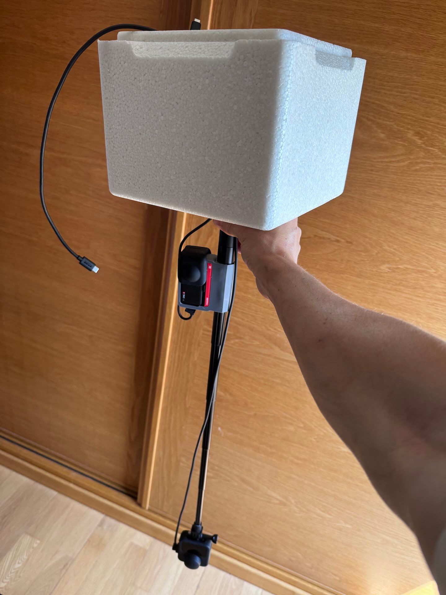
I trusted the GoPro Max2 more for its higher resolution, better dynamic range and color science, but it was also using up much more battery in freezer tests (the stratosphere is really cold), and its removable lenses proved a challenge when it came to avoiding condensation. Even if this Insta360 model is technically inferior, its lenses aren't removable so they shouldn't have any moisture on the inside, plus having backup for such a unique event is always a good idea. An especially large power bank was also provisioned for the GoPro.
On the electronics front, the recommended StratoFinder (SIM-based) and Spot Trace (great hardware but an abusive business model) GPS trackers for recovering the probe after landing were complemented with an Apple Airtag to help with the very last part of the search. For data recording, the STRATO4 tracker includes a wide range of useful sensors and GPS coverage at high altitude, but I also attached a Garmin Venu to the board, both as a fun experiment (will it survive the mission with its own battery?) and an admittedly weak backup plan in case the STRATO4 failed. As a commercial watch the Venu shouldn't be able to record GPS above a certain altitude, but it also has a barometer that would allow us to infer altitude data throughout the mission. The barometer data can be made available with FIT Weather Record.
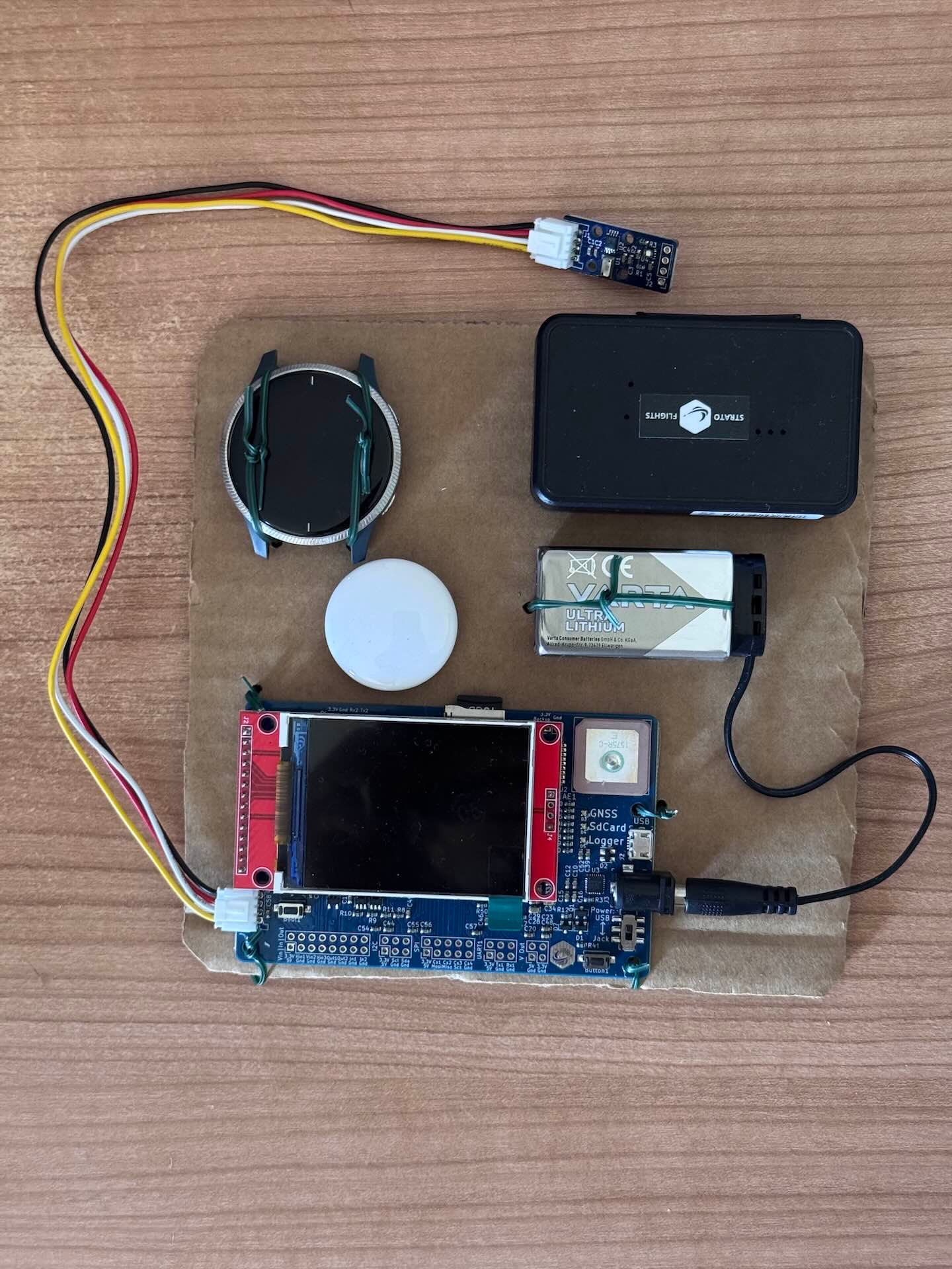
It would have been great to also record GPS data with the GoPro to find out how high it can get a signal from, and it would have been a great backup data source, but its high battery consumption was too much of a concern, so I disabled GPS recording.
Launching a weather balloon from Spain requires sharing your flight plan with the ENAIRE authority. I was making these plans months in advance, so I could not share a precise trajectory until the weather for the day was predictable, but they accepted a range of maximum boundaries. Additionally, AXA reviewed all the documents and provided insurance for the flight.
Finally, StratoFlights doesn't directly sell the balloon gas (helium), so we find a good provider in Spain with Carburos Metálicos: A 20 litre 300 bar bottle provided enough gas in a single light-weight package that also includes a pressure valve, and their flexible inflation pistol was also convenient.
Objectives
One could assume recording an eclipse from the stratosphere would provide a better view of the sun and its corona, since the atmosphere doesn't interfere with the photos like it does on the ground, but the reality is pointing a long lens (zoomed in, so to speak) at a small target from an unmanned weather balloon is incredibly hard. 360 cameras solve this by pointing everywhere at the same time, but their angular resolution is really poor even with the newest models, so they cannot beat anything done from the ground with a telescope or a heavy long lens. What's interesting from the stratosphere during a solar eclipse is Earth: specifically, the deep black shadow that the moon casts on the ground (and on the atmosphere).
Other secondary mission objectives were:
- Recording high altitude data from multiple sensors (barometer, temperature, accelerometer, humidity, UVA light…)
- Testing the cameras and electronics under stratospheric conditions
- Producing multiple videos that could showcase features of Telemetry Overlay, both in 360 and flat formats
- Having fun
Launch
Given the complexity of a first time launch, I prioritised being close to a family house where friends could assist both the launch and the recovery efforts. This meant not being dead center in the totality path, which would probably result in the probe not being completely obscured at high altitudes, but again the objective was to film the umbra and the difference between light and dark ground, not the sun itself, so this was fine.
The launch checklist planned way in advance ended up being very effective, but much longer than expected. It was stressful to say the least, but after a small delay the balloon and the probe took off in time to capture the umbra, if not from the top of our trajectory, clearly from stratospheric flights.
Eclipse
We then enjoyed the first total eclipse of our combined lifetimes with friends and family. An experience we will never forget! Personally, the black ball covering the sun felt like a 3D object, and much much closer than it actually was. Hard to grasp and impossible to convey with photos or videos.
And right before sunset, the search for the probably-about-to-land probe began. There would be no footage and almost no data without that!
Recovery
The Spot Trace tracker continued to provide probe locations throughout the mission, even at altitudes where we weren't expecting so, but altitude data was missing or inconsistent, so we needed to be in the vicinity of the predicted landing spot and wait for the StratoFinder to catch a mobile signal and notify the landing. We were very surprised when the probe landed almost exactly in the spot where the StratoFlights app predicted it would, based on the amount of helium and the weather at each altitude. Very impressive, and it made for an easy recovery (from fields next to a road), as we had fine-tuned the launch site based to aim for an easier recovery too!
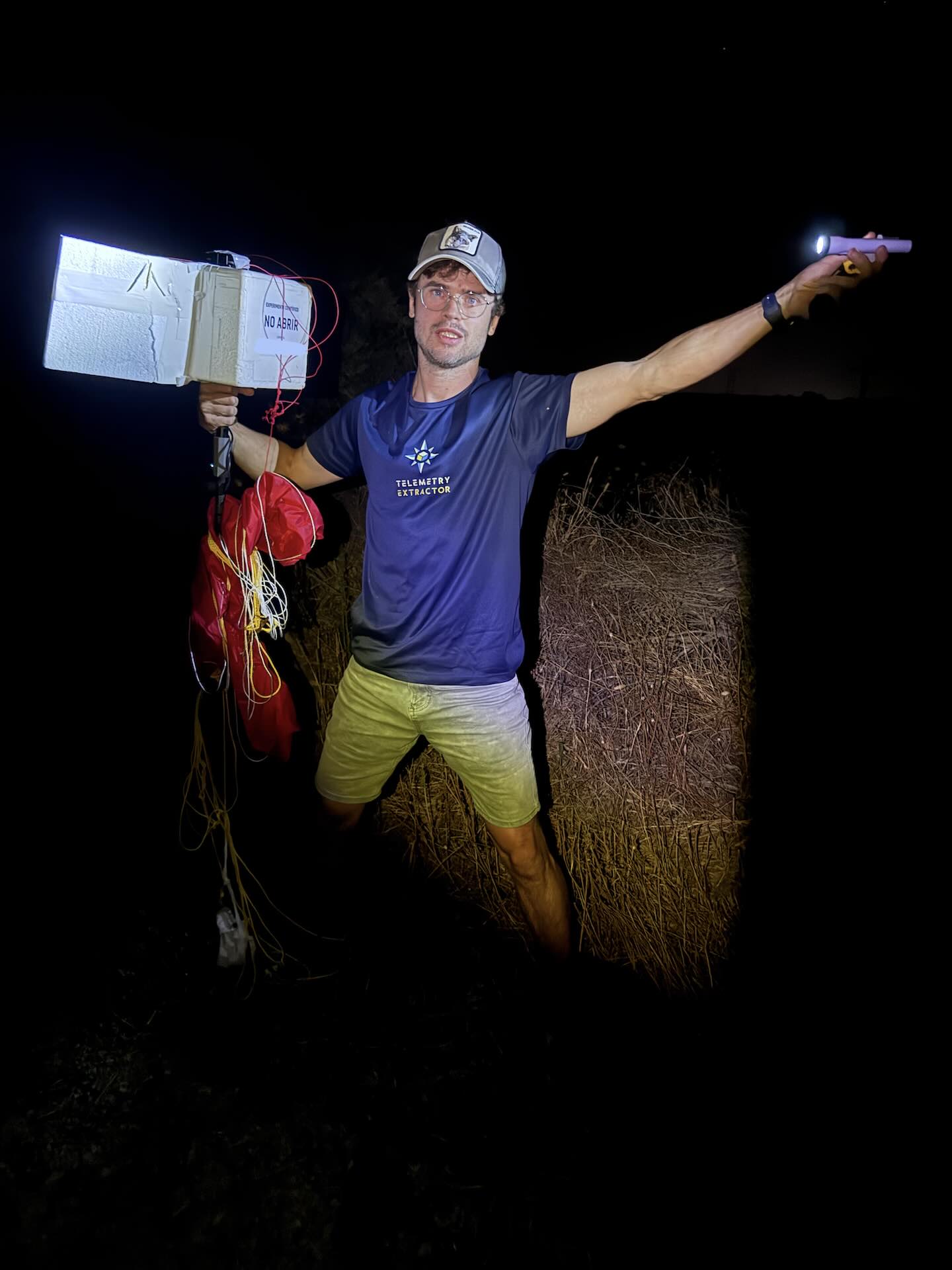
Both cameras were still recording (or so it seemed) and all the electronics except the Garmin were still on. This was starting to look like a success!
Footage and data review
The STRATO4 recorded perfectly good data throughout the mission! No need for a backup, but the Garmin Venu did really well for an unpowered watch that wasn't designed for this. It recorded GPS up to 20,000 meters and then barometric data up to about 31.000 meters high. Then it seems to have crashed or turned off at minus 11 degrees Celsius and 8 hPa (really low pressure, almost a vacuum).
The GoPro Max2 had indeed recorded the entire flight. Despite great efforts to dry the inside of the camera to prevent condensation, droplets and then ice crystals had still formed at the very cold lower regions of the stratosphere, precisely where we were during the eclipse. The umbra was there and the footage was an impressive achievement, but maybe not as commercially appealing as it could have been. Automatic stabilization was also struggling (maybe because of the extreme temperature changes, or the constant attitude changes, not sure), so creating clean time lapses of the umbra progressing would be a challenge. The Insta360 should at least have recorded everything without condensation… right?
Unfortunately no. Water still condensed inside the sealed lenses. On top of that, the video files recorded after the balloon burst were either corrupted or entirely missing. Overall the image quality, color and resolution were orders of magnitude worse than the GoPro, so the GoPro it was! Back to the editing software to clean up the footage and select the best shots. Here's the first summary video.
Results and observations
Here are some of the key data points from the mission:
- Maximum altitude: 38.7 km (24.1 mi, 127,000 ft)
- Lowest temperature: -58°C (-72°F)
- Minimum pressure: 3.3 hPa (0.3% compared to sea-level)
- Ascent time: 2 hours and 2 minutes
- Descent time: 53 minutes
- Ascent speed: ~5 m/s (18 km/h, 11 mph, 984 fpm)
- Maximum descent speed: 85 m/s (306 km/h, 190 mph, 17,000 fpm)
- Ground distance covered: 103.2 km (64.1 mi)
- Linear distance from launch to landing: 27 km (17 mi)
We caught the totality of the eclipse at about 24 km high, a bit lower than we were aiming for, but most of the atmosphere was already below us, which provided the global view and the black sky I was expecting. Due to the hazy atmosphere, ground visibility wasn't great, but luckily some high clouds (or wild fire smoke) made the view and the effects of light changes more interesting.
The balloon was expected to burst between 35 and 36 km high, but it lasted until almost 39 km! This provided us with an amazing view of Earth and the atmosphere. Combined with the delayed launch time and the camera settings optimized for the very bright conditions of the stratosphere, this meant the the last part of the descent isn't usable in the video, but we get to enjoy a beautiful red sunset on the way down. You can enjoy the mission in more detail and extent with this 360 video.
We were surprised to see planes in the area despite having received permission to launch there. They can be found in the 360 video by looking up when you hear them during the ascent. The sources we consulted said this was normal and under control by aviation authorities and pilots
Flat earth
Many weather balloon videos on the internet are eventually flooded by comments from flat earthers. I personally find flat-earth theory an interesting thought experiment, and some of their proponents pose actually challenging questions that most people without a science background cannot answer. I think they unfortunately tend to blindly reject any evidence that contradicts their flawed model (cannot make predictions or explain most phenomena) of Earth. These related experiments do not come from a suspicion that the Earth is flat (there are hundreds of ways to disprove that from the ground). They are rather a fun extension of the mission and the consequence of thinking about geometry, distances, and visual representations. I am in no way trying to mock flat earthers, on the contrary, they are welcome to the comments section of the videos as long as they keep things civil.
On the one hand, we recorded a reference sheet with straight lines right before launch. This allowed us to calibrate the camera for straight lines at different angles, thus ensuring any lines that appeared curved in the video were indeed curved. A common criticism that stratospheric videos get is that the lenses used are fisheye lenses. Fisheye is just one of the many projections one can use to represent a sphere (or one of its sections) on a flat surface. A projection always prioritises something: shape, size, distance… and each has its purpose and use cases. If you know the intrinsics of a camera lens, you can convert between its projection and a different one with math, It's a solved problem and it can be trusted. The GoPro Max2 uses fisheye lenses (needed for its wide FOV) and then stores the image with a custom equiangular cubemap projection. Stitching software then converts it to the more common equirectangular projection, and (despite extreme fisheye shots look extremely cool) in the first video we extracted rectilinear (implying straight lines appear straight) views from that.
From 39 km high, only a very tiny section of Earth is visible: about 12 degrees from end to end with ideal weather conditions, way less if we want to identify land features with the atmosphere and lighting on mission day. This means the amount of curvature we can see is very little (but it's clearly there). However, if Earth were flat both the sky and the ground would extend indefinitely (until the ice wall that is), so both sky and ground should always take up exactly 50% of a 360 view. If the ground is any lower, it means it's curving away from us and we are on top of a sphere. We can visually check this with an overlaid flat earth horizon line (at 50% of the 360 view) in the 360 video (near the highest point of the mission).
Device performance
Here's a subjective comment on how each device performed.
STRATO4
Almost flawless. This is the data tracker from StratoFlights. It records really interesting data streams and didn't have any issues in the tough conditions of near-space. There were some minor issues in the data of the CSV, but nothing Telemetry Overlay cannot adjust.
GoPro Max2
Really good. It used up less battery than expected. Got really hot before launch but temperatures came down once air started flowing. Fogging is a real issue and it happened despite lots of efforts to prevent it. Stabilization wasn't as good as with ground activities. I hope we can enable its GPS in a future mission to test its capabilities.
Insta360 OneR
Bad. It fogged up despite its lenses not being replaceable. It crashed and lost some of the footage. Its color science, resolution and image quality are orders of magnitude below the GoPro, but we can't really judge it on that front, as it's from an older generation of cameras.
StratoFinder
Great. It lost connectivity immediately after launch, which was scary, but recovered it briefly before landing and provided the landing time and location accurately. More detail flight path data is visible afterwards in the app, so I wish that could be extracted as a backup data recording source.
Spot Trace
Great. It provided latitude and longitude data every 5 minutes throughout the mission, even at the highest altitudes. The marketing on their pricing is clearly misleading. If you use it for a brief period you will have to pay a bunch of one-time fees (and then pay them again if you use it some other time). The data can be downloaded afterwards, so it acts as a very coarse backup data recorder, however recorded altitude data seems to be incorrect.
Garmin Venu
Ok. I wasn't expecting it to stay awake for the full mission, but it did survive most of the ascent. GPS locations were lost above 20 km (probably due to legal limitations) but altitude could be derived from the barometric readings. It could be a backup source of altitude data if paired with a power bank, I think.
Apple AirTag
Good. We didn't end up needing it because the other trackers functioned properly, but it notified us about the location of the probe when the first humans with an iPhone (us) approached it. It could be a good backup recovery plan in case someone finds the probe or happens to walk nearby. Obviously it has no use in remote areas.
Afterword
And that's pretty much it for an incredibly fun and educational experience! We achieved most of the goals to a great extent, and while the videos didn't get much attention (I think viewers expected to see the eclipse better than from the ground, not the umbra) I love the result and have actually spent lots of time on VR headset enjoying the view and paying attention to little details.
I hope we can fix lens fogging for the next attempt and nail the launch time better. Another eclipse is coming to the south of Spain next year, but it may require a water launch/or landing, which adds to the complexity of it all. Still not sure if that will be mission 2. Thanks for reading!